Clouds: Types, Heights, and What Pilots Need to Watch
For student pilots, Clouds are more than something in the sky. They are among the first weather signs to warn of turbulence, reduced visibility, icing, precipitation, or unstable air. The FAA’s Aviation Weather Handbook explains that visible moisture formations help pilots visualize weather conditions and potential hazards, which is exactly why cloud recognition is taught so early in flight training.
That is also why Clouds cause trouble for inexperienced pilots. A pilot who cannot judge a layer properly may lose visual reference, misread the weather ahead, or fly too close to a dangerous buildup. In private training, especially, staying clear of these formations is not just a technical rule. It is a safety habit that protects the pilot from entering weather they are not trained to handle.
Why Clouds matter so much to pilots
A pilot does not look at a formation only to name it. They look at it to predict what kind of air may be inside or around it. The FAA notes that visible moisture can indicate turbulence, precipitation, icing, and reduced visibility. That is why a good weather scan starts long before the aircraft reaches the area.
This also connects directly to cockpit workload. If the outside picture becomes less reliable, the pilot has to depend more heavily on instruments and disciplined control. That is one reason flight instruments become more important as weather and visibility become less forgiving.
What these formations often warn a pilot about
|
What the pilot sees |
What it may suggest |
|---|---|
|
Thin high ice formations |
Changing weather, jet-stream influence, moisture aloft |
|
Dark layered overcast |
Continuous precipitation and low ceilings |
|
Towering vertical buildups |
Strong instability, severe turbulence, storms |
|
Low grey layers |
Reduced ceiling, poor visibility, trapped moisture |
|
Fast-growing convective shapes |
Updrafts, downdrafts, icing, possible thunderstorm development |
That is why reading the sky matters. A pilot who understands these signs early will make better decisions about route, altitude, and whether the flight should continue as planned.
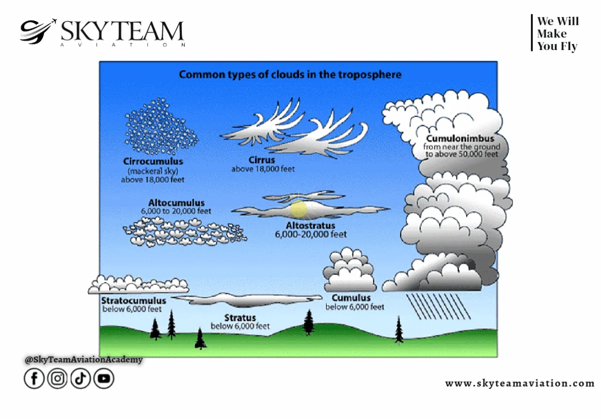
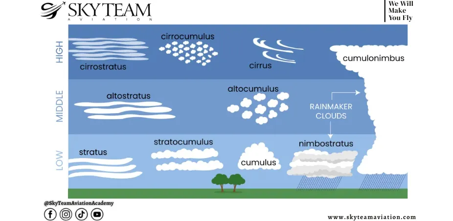
How Clouds are classified
The standard beginner system uses two main ideas: shape and height. NOAA and UCAR both describe the common classification groups as high, middle, low, and vertically developed formations, while also linking certain shapes to stable or unstable air.
The three classic form families are cirriform, stratiform, and cumuliform. Cirriform formations are usually high and icy. Stratiform layers are flatter and more stable in appearance. Cumuliform buildups are more closely associated with instability and vertical growth. This system is useful because it helps the pilot read not only what is there now, but also what the atmosphere is doing.
The main classification table
|
Group |
Typical character |
Usual composition |
What it often tells the pilot |
|---|---|---|---|
|
Cirriform |
Wispy, fibrous, thin |
Mostly ice crystals |
High moisture aloft, changing weather possible |
|
Stratiform |
Layered, spread out |
Water droplets and/or ice |
Stable air, widespread cover, and lower ceilings are possible |
|
Cumuliform |
Heaped, puffy, building vertically |
Water droplets and/or ice |
Instability, rising air, possible turbulence |
This is where air masses fit naturally into the bigger picture. Stable or unstable source air helps explain why one day produces flat layers, and another builds vertical towers.
How pilots describe the sky: cloud cover in oktas
Oktas are the standard way meteorologists describe how much of the sky is covered by cloud. Instead of saying the sky is “a little cloudy” or “very cloudy,” the sky is divided into eight equal parts and the amount of cloud is reported in eighths. That gives pilots and forecasters a much clearer way to describe cloud amount without vague language.
In aviation, this matters because cloud amount is not just cosmetic. It helps pilots judge how open the sky is, whether a ceiling may exist, and how conditions are changing. Once a student understands oktas, METARs and weather observations become much easier to read.
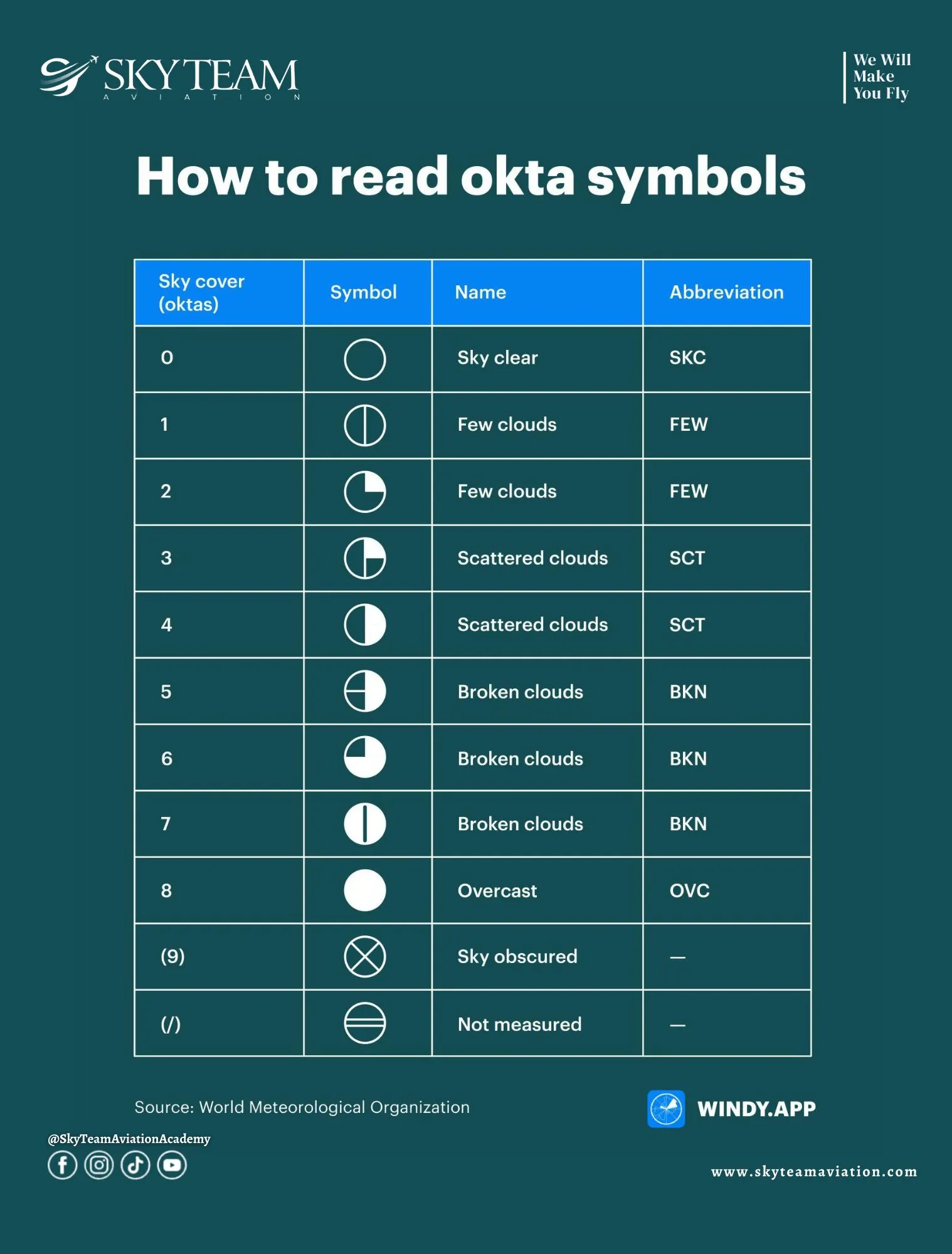
What Oktas actually mean
An okta is one eighth of the sky dome. If only one eighth of the sky is covered, that is 1 okta. If the whole sky is covered, that is 8 oktas. This system gives a simple visual scale from clear sky to complete overcast.
This is useful because it creates a common language. A pilot, controller, and forecaster can all understand the same sky condition without relying on subjective wording. That makes cloud reporting much more practical in real flying.
How cloud cover is linked to OKTA values
The usual aviation interpretation works like this:
|
Okta value |
Meaning |
Common aviation description |
|---|---|---|
|
0/8 |
No cloud |
Clear |
|
1/8 to 2/8 |
A small amount of cloud |
Few |
|
3/8 to 4/8 |
Noticeable but not dominant cloud |
Scattered |
|
5/8 to 7/8 |
Most of the sky is covered |
Broken |
|
8/8 |
Full cloud cover |
Overcast |
This matters because broken and overcast conditions can create a ceiling, while few and scattered generally do not. So oktas are not only about appearance. They can directly affect how a pilot thinks about visibility, legal minima, and route conditions.
Why oktas matter to pilots
Pilots use cloud-cover information to judge how much visual reference may be available and whether the sky is becoming more restricted. A sky with 2 oktas is very different operationally from one with 7 oktas, especially if the lower layer is sitting close to the ground.
For student pilots, oktas are helpful because they make weather reports less abstract. Instead of guessing what a sky report means, they can picture how much of the sky is covered and how that might affect the flight.
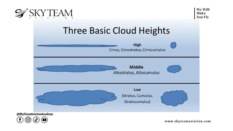
What pilots mean by high, middle, and low layers
Meteorologists and aviation weather systems often sort cloud formations by cloud base height. NOAA gives typical ranges as low: below 6,500 feet; middle: about 6,500 to 23,000 feet; and high: roughly 16,500 to 45,000 feet, with seasonal overlap between the middle and high bands.
This overlap matters because the atmosphere is not fixed year-round. A band that seems “high” in one season or region may sit lower in another. For a pilot, the exact height matters more than the label. A low layer affects ceilings and visual flight. A high, icy sheet may primarily signal an upcoming weather change rather than immediate operational limits.
Height bands at a glance
|
Height band |
Typical examples |
Why pilots care |
|---|---|---|
|
Low (surface to ~6,500 ft) |
Stratus, stratocumulus, nimbostratus, some cumulus |
Can restrict VFR flying, reduce ceiling, and hide terrain |
|
Middle (~6,500 to 23,000 ft) |
Altostratus, altocumulus |
Can signal larger weather systems and changing conditions |
|
High (~16,500 to 45,000 ft) |
Cirrus, cirrostratus, cirrocumulus |
Often hint at upper-level moisture and future weather change |
|
Vertical development |
Cumulus, cumulonimbus, deep nimbostratus |
Can produce turbulence, storms, icing, and severe hazards |
If you want a broader foundation first, the full cloud guide can sit earlier in the reading path, while this article focuses more directly on what matters to a pilot in training.
Which layers usually form in stable air
Layered formations usually form in more stable air. They spread horizontally because the air is not rising violently enough to build deep towers. These include stratus, altostratus, cirrostratus, and, in many cases, nimbostratus. NOAA and UCAR both describe layered types as flatter and more widespread than convective buildups.
For pilots, stable layers can still be a serious problem. They may not look dramatic, but they can hide sun, lower ceilings, produce steady precipitation, and reduce the visual margin needed in private training. A calm-looking overcast can still be operationally restrictive.
Useful clues in layered formations
-
Broad, sheet-like coverage usually suggests more stable air
-
Thick grey layers can mean steady rain or snow rather than brief showers
-
Lower sheets often affect visibility and legal VFR clearance sooner than tall buildups
That is why a pilot should never mistake “not dramatic” for “not important.”
What dangerous Clouds look like before they become a problem
The most dangerous formations for light-aircraft flying are usually the ones with strong vertical development. Cumulonimbus in particular is the major threat. FAA thunderstorm guidance states that cumulonimbus clouds are thunderstorm clouds and that thunderstorms contain some of the most severe weather hazards in aviation, including severe turbulence, lightning, hail, heavy precipitation, and strong gusty winds.
This is why vertical buildups matter so much in training. A small fair-weather cumulus may be harmless, but once a convective tower keeps building, the pilot has to start thinking about strong updrafts, downdrafts, ice, and loss of safe separation. If the weather picture is shifting in that direction, thunderstorms become the more specific topic a student should understand next.
Why cumulonimbus deserves special caution
|
Feature |
Why it is dangerous |
|---|---|
|
Great vertical height |
Hard to climb above in most aircraft |
|
Strong updrafts and downdrafts |
Can exceed aircraft climb capability |
|
Heavy moisture and ice |
Increases icing and precipitation hazards |
|
Embedded turbulence |
Can extend well outside the visible core |
|
Lightning and hail |
Add direct structural and operational danger |
A pilot does not need to fly into one of these towers to be at risk. The surrounding air can still be rough, unstable, and deceptive.
What should student pilots focus on first?
Early training does not require students to become meteorologists overnight. It requires them to recognise the basic types, understand the likely hazards, and avoid conditions that their licence and experience do not support. That is why flight schools teach sky recognition alongside weather reports, forecasts, and visibility rules.
As training progresses, the same weather knowledge becomes even more important for instrument flying. A pilot working toward an Instrument Rating needs to treat layers, ceilings, and moisture as operational facts rather than visual curiosities. By that stage, recognising formations is only one part of the skill; the bigger part is knowing what they mean for the flight ahead.
Conclusion
Once you understand Clouds, the sky becomes easier to read. You stop seeing random shapes and start seeing clues about stability, moisture, ceilings, turbulence, and possible storms. That is why this topic matters so much in private training: it helps pilots avoid weather they are not prepared to handle and make safer choices before conditions become dangerous.
The most useful habit is not memorising every Latin-sounding name in isolation. It is learning to connect appearance, height, and behaviour to what the aircraft may experience. That is when weather study starts to become real aviation knowledge rather than classroom theory.